



















Two droughts: how lack of rainfall and low soil moisture aggravate fires in the Amazon

The study also points to the influence of El Niño, which changes air circulation, reduces rainfall, and compromises groundwater's role in maintaining soil moisture during long periods of drought.

 03/02/2025 - Publicado há 1 ano

Text: Júlio Bernardes

Leia este conteúdo em PortuguêsA group of scientists working with USP’s Institute of Geosciences (IGc) has revealed how the combination of two forms of drought increases the risk of forest fires in the Amazon. According to the research, meteorological drought, characterized by a lack of rainfall, favors the emergence of fire outbreaks, while hydrological drought, by decreasing soil and vegetation moisture, creates a highly flammable environment. The researchers also point out that El Niño events, which change air circulation and reduce rainfall, increased the area burned by 244% between 2015 and 2016 and that prolonged droughts compromise the role of groundwater in maintaining soil moisture. The study’s results are reported in an article published in the journal Science of the Total Environment last December.

The research covered the entire Amazon Basin, the largest river basin on the planet, with an area of approximately 7.4 million square kilometers (km²). “Meteorological drought is characterized by a decrease in rainfall in a region during a specific period,” Professor Bruno Conicelli, from USP’s Institute of Geosciences (IGc), who is part of the group of authors of the article, told Jornal da USP. “It is a direct response to climate variations and has immediate impacts on the surface hydrological cycle.”

“Hydrological drought refers to a reduction in water availability in water bodies such as rivers, lakes, and aquifers,” explains the professor. “Unlike meteorological drought, it has a prolonged effect because it depends on the time needed for the soil and aquifers to react to variations in rainfall”

foto de um homem branco, com cabelos pretos curtos, olhos escuros e armação de óculos escura. Ele usa um blazer preto e uma camisa clara.

Bruno Conicelli - Photo: CV Lattes

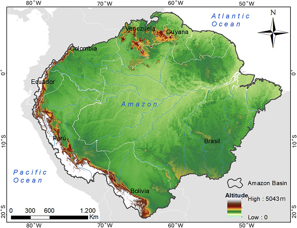
mapa da Amazônia, representada na cor verde.

The Amazon is home to the largest river basin on the planet, with 7.4 million square kilometers (km²); variations in the drop in groundwater
levels reinforce the need for localized management and conservation strategies - Photo: taken from the article

Águas subterrâneas e El Niño

The main goal of this study was to understand how meteorological and hydrological droughts affect forest fires in the Amazon, with an emphasis on the role of groundwater and the influence of El Niño events. “In addition, it sought to assess the temporal distribution of hydrological drought at different soil depth levels, analyze the relationship between meteorological and hydrological drought indicators, and investigate the impact of El Niño events on worsening drought conditions and increasing the area affected by forest fires between 2004 and 2016,” says Conicelli.

The primary data sets used in the analysis include hydrological drought indicators (DI), obtained from the GRACE (Gravity Recovery and Climate Experiment) satellite, and the Standardized Precipitation Index (SPI), calculated from data from the Tropical Rainfall Measuring Mission (TRMM) satellite. The Global Fire Emissions Database (GFED4) provided data on the monthly fraction of burnt area, allowing for the identification of temporal and spatial patterns in the fires. The intensity of El Niño Events (ENSO) was assessed using the Oceanic Niño Index (ONI), which ranks episodes into weak, moderate, strong, and very strong, based on data obtained from the Golden Gate Weather Service. The professor reports that all the data was processed and analyzed using statistical techniques and advanced computer tools, guaranteeing the reliability of the results.

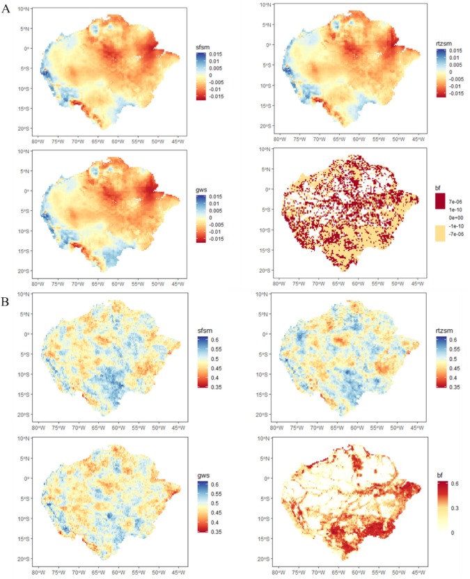
“The hydrological drought indicators (DI), derived from GRACE, have made it possible to assess how groundwater reserves have been affected over time. However, although it considered the basin as a whole, the results highlighted specific regional patterns,” says Conicelli. “In the northeast of the Amazon, for example, a lower moisture concentration was observed in all the soil layers analyzed, making this region more vulnerable to forest fires. On the other hand, in the south of the basin, moisture tended to decrease at deeper levels, such as aquifers, indicating a slower response of groundwater to changes in precipitation. These patterns emphasize the environmental heterogeneity of the Amazon and the need for localized management and conservation strategies.”

According to the research, El Niño events have had a significant impact on intensifying drought conditions and increasing forest fires in the Amazon. “During periods of very intense El Niño, such as 2015 and 2016, the burnt area increased by up to 244% compared to the annual average. This climatic phenomenon reduces rainfall in the Amazon basin by altering atmospheric circulation patterns, which prolongs periods of drought. As a result, the vegetation becomes drier and more susceptible to fire,” says the professor. “Groundwater plays a critical role in this context. Because they are water reserves that respond more slowly to changes in rainfall, they sustain soil moisture during periods of meteorological drought. However, when groundwater levels drop due to prolonged droughts, recovery is slow, increasing the region’s vulnerability to prolonged periods of aridity and, consequently, fires”.

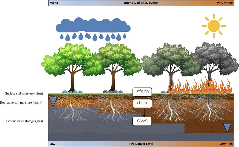
imagem com fundo branco mostra, à esquerda, nuvens de chuva acima de árvores verdes e, abaixo, a representação das raízes embaixo do solo. À direita, o sol acima de outras duas árvores acinzentadas, com fogo nas raízes acima do solo.

Under normal climatic conditions, groundwater helps maintain soil moisture, however, extreme events such as El Niño, which reduce rainfall and lead to prolonged droughts, increase the risk of forest fires - Photo: taken from the article

oito mapas da Amazônia mostram oscilação dos índices no período entre 2004 e 2016

Maps show variation within the Amazon in the Hydrological Drought Indicator (DI), surface soil moisture (sfsm), root zone soil moisture (rtzsm), groundwater (gws), and a fraction of burned area (bf), as well as the oscillation of the indices in the period between 2004 and 2016 - Photo: taken from the article

Sustainable management

According to the IGc professor, the research has revealed that both forms of drought act in synergy to significantly increase the extent and severity of fires in the Amazon. “Meteorological drought, with its rapid onset, can trigger favorable conditions for fire,” he points out, “while hydrological drought, by reducing soil and vegetation moisture, creates a highly flammable environment.”

“It is essential to implement early warning systems based on continuous monitoring of groundwater, climate indices, and hydrological and meteorological drought indicators,” recommends Conicelli. “Technological tools, such as the GRACE and TRMM satellites, play a crucial role in providing real-time data, allowing for the prediction of critical events, such as prolonged droughts and increased risk of fires.”

“In addition, sustainable land management should be prioritized, with measures to reduce deforestation and promote agricultural practices that conserve the soil and native vegetation,” suggests the professor. “Another important point is the need to invest in environmental education to sensitize local communities to the impacts of climate change and engage them in conservation practices.”

An interdisciplinary team of researchers carried out the work, including Naomi Toledo, Gabriel Moulatlet, Gabriel Gaona, Bryan Valencia, Ricardo Hirata, and Bruno Conicelli, who signed the article. The participating institutions were the Universidad Regional Amazónica Ikiam (Ecuador), the University of Arizona (USA), and the Groundwater Research Center (CEPAS-USP) of the IGc (Brazil).

English version: Nexus Traduções


Política de uso 
A reprodução de matérias e fotografias é livre mediante a citação do Jornal da USP e do autor. No caso dos arquivos de áudio, deverão constar dos créditos a Rádio USP e, em sendo explicitados, os autores. Para uso de arquivos de vídeo, esses créditos deverão mencionar a TV USP e, caso estejam explicitados, os autores. Fotos devem ser creditadas como USP Imagens e o nome do fotógrafo.