Study confirms the size of the largest cave entrance in Brazil and investigates flood waves

Precision technology measured the height of the Casa de Pedra portal at 197 meters; rainfall analyses indicate flood risk inside the cave

 27/02/2026 - Publicado há 3 meses

By: Tabita Said

A natural heritage site of the State of São Paulo features the largest cave entrance ever measured in the world – Photo: Thomas Fuhrmann/Wikimedia

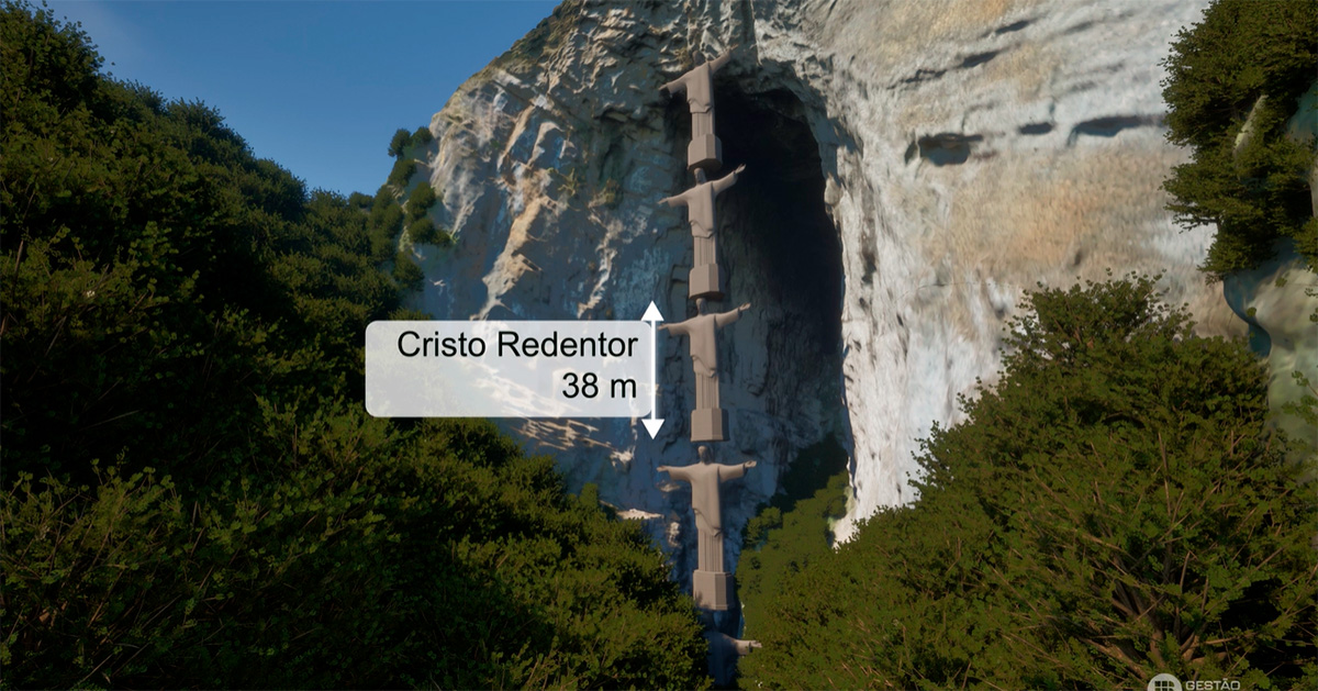
Ongoing research at USP’s Institute of Geosciences (IGc) has confirmed the exact measurement of the portal of Casa de Pedra, a cave with a monumental entrance located in the municipality of Iporanga, within the Alto Ribeira Tourist State Park (Petar), in the Vale do Ribeira region of São Paulo. The measurement was conducted using airborne Lidar – a remote sensing system that performs pulsed laser scanning emitted from a drone. This high-precision technology, capable of collecting millions of points per second, generated a 3D mapping and measured the height of the Casa de Pedra cave entrance at 197 meters, potentially reaching even greater figures when considering the uppermost section. 

Data still being processed by the researchers and obtained by Jornal da USP confirm that one-hour rainfall events increased the water level by more than 2 meters at the cave’s exit – a risk factor for exploration activities. The survey may assist in planning visits and managing the cave, which extends approximately 3 kilometers in length. 

Marked by imprecision and controversy, Casa de Pedra has been closed to visitors since 2003, when a group of tourists and a guide were struck by a flash flood. One tourist and the guide accompanying the group drowned. Currently, the site is accessed only by authorized researchers and members of the Civil Defense. 

“The cave, for example, has never been listed in the Guinness World Records. We did not even know its exact measurement until now”, explains Nicolás Strikis, a professor at USP’s IGc and one of the researchers involved in the measurement. According to him, after its closure, the site faded from public awareness. “It is as if the state of São Paulo possessed something comparable to Guanabara Bay – a major asset not only in tourism but also environmentally, aesthetically, and naturally – simply ignored”, he told Jornal da USP.

Following the survey, it was possible to affirm that Casa de Pedra indeed has the largest cave entrance in Brazil and, very likely, in the world. “With these landscape characteristics, it is the largest portal measured in the world to date”, Strikis emphasizes.

“We have in São Paulo a heritage site that has long been somewhat neglected – the Casa de Pedra cave – even though it is one of the most beautiful cave portals in Brazil and worldwide. It is truly remarkable: you have dense ombrophilous Atlantic Forest. A river runs through a narrow canyon and suddenly you encounter what we call a sinkhole – where the river disappears beneath the mountain” – Nicolás Strikis

Guide Silnei Florindo da Silva and USP researcher Vanessa Bohrer during movement inside the Casa de Pedra Cave - Photo: Melissa Medina
View of the sinkhole of the Casa de Pedra Cave, with the Maximiano River flowing into the cave – Photo: Paulo Natanael Messias dos Santos

Fear of rain

The 3D mapping of Casa de Pedra emerged during the master’s research of Vanessa Faria Bohrer at USP’s Institute of Geosciences (IGc), under the supervision of Strikis. In her study, Vanessa measures the discharge of the river spring that flows through the cave, monitoring flood waves within Casa de Pedra.

“There has been a speleological management plan for this cave since 2010, but hydrological monitoring was still lacking for park authorities to evaluate a possible reopening”, explained the master’s student, who periodically shares fieldwork updates on the Projeto Casa de Pedra Instagram page. Vanessa highlights the challenges involved in the research, with field collections conducted every 2 months and requiring extensive planning due to the imminent risk of flooding.

“It is demanding fieldwork, a 3-hour hike to reach the portal, but extremely rewarding. We have always believed in the project’s impact on society, both for local tourism and nationally and internationally”, she says. In addition to relying on weather forecasts, Vanessa and Strikis receive support from hydrologists at the Environmental Research Institute (IPA) and members of the Civil Defense of Iporanga during data collection. The work involves 4 days of dedication: the first for travel to Iporanga; the second for planning the trip to the resurgence point, where the underground waters of the Maximiano River re-emerge inside the cave. The third for data collection at the portal; and the fourth for recording precipitation data at the river’s headwaters in the Caboclos sector, in the center of the park.

According to Strikis, Casa de Pedra is an important heritage site for which no historical measurement records exist. “In addition to generating unprecedented scientific results, this study could also support the management of public policies in the area”, he states. Although there is the possibility of reopening the cave for visitation, the researcher stresses that it is a highly challenging environment requiring extensive experience in subterranean settings. “It is as if you were walking through collapsed ruins, with the river flowing and several sections without escape areas. It is technical. It is not conventional tourism. I would not recommend it casually”,  he concludes.

Research data still under processing indicate the occurrence of flood episodes marked by significant rises in water levels at the river’s resurgence area inside the cave. Rainfall of 60 millimeters per hour (mm/h) resulted in a 2.17-meter increase at the beginning of last year; records from December showed that rainfall of 50 mm/h caused the water level to reach 1.90 meters in the same chamber. Less intense rainfall, at 10 mm/h , was also sufficient for the river to rise to 1 meter in the resurgence area.

“The time interval between the peak rainfall and the peak water level was approximately 1.5 hours. In other words, it was quite fast, though not instantaneous – there would still be time for evacuation”, Vanessa explains. She emphasizes that the data are still being analyzed using different methods to determine factors such as the average time for water level rise under varying rainfall intensities, as well as the average recession time – the time required for the river to return to what is considered its normal level.

The research group compared the size of the entrance to five Christ the Redeemer statues stacked on top of one another - Photo: Gestão Engenharia
High-precision mapping generated a 3D model of the cave, revealing the magnitude of the limestone opening - Photo: Gestão Engenharia

Collaboration and sense of belonging

The 3D mapping of the Casa de Pedra cave entrance was conducted through a partnership between USP, the Forest Foundation (Fundação Florestal), Gestão Engenharia – the project’s sponsor – and independent speleologist Thiago Ferreira Lima, from the state of Minas Gerais. The survey confirmed the monumental size of the portal – even 5 Christ the Redeemer statues stacked together would not reach the top of the cave entrance -and also resulted in a massive collection of images that will contribute to understanding its evolutionary geological process.

“We can better understand its morphology, because it is difficult: the riverbed slopes downward and you never have a single image showing the entire cave, from base to ceiling. The 3D model allows us to visualize that”, explains Nicolás Strikis. He adds that the research group is also working on the creation of a physical scale model, which will remain with the local community.

Due to the high resolution of the images generated by Lidar technology, the group produced a “digital twin” – a virtual model preserving the metric characteristics of the point cloud, which originally contains millions of data points. The material will be further developed in a forthcoming scientific publication.

More information: strikis@usp.br, with Nicolas Misailidis Strikis 

English version: Nexus Traduções, edited by Denis Pacheco


Política de uso 
A reprodução de matérias e fotografias é livre mediante a citação do Jornal da USP e do autor. No caso dos arquivos de áudio, deverão constar dos créditos a Rádio USP e, em sendo explicitados, os autores. Para uso de arquivos de vídeo, esses créditos deverão mencionar a TV USP e, caso estejam explicitados, os autores. Fotos devem ser creditadas como USP Imagens e o nome do fotógrafo.